A strong tropical wave over the southeast Bahamas is likely to become Tropical Storm Humberto over the weekend. The National Hurricane Center began issuing advisories on Potential Tropical Cyclone Nine (PTC Nine) Thursday afternoon.
Forecasters at the center have noted that uncertainty is "greater than normal", and they urge Floridians to stay informed of future forecasts because tropical-storm-force winds and rain are possible across portions of the peninsula this weekend.
There are two possible scenarios that could unfold this weekend, with two very different outcomes from the eventual track and strength of PTC Nine. The National Hurricane Center has seemingly split the difference between the two with their first "cone of uncertainty."
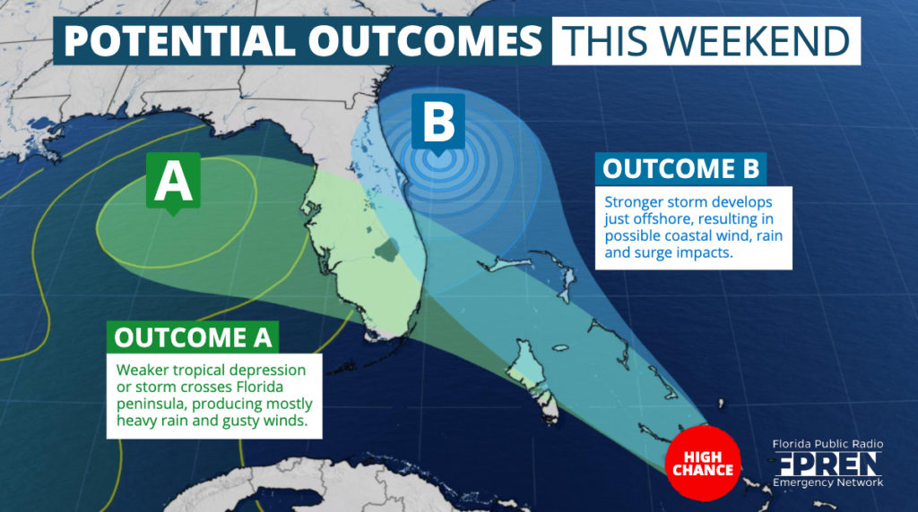
There are considerable differences between the most reliable models where PTC Nine will go and how strong it may get. The U.S. global model is forecasting a weaker system moving across Florida late Friday into Saturday before heading toward the central Gulf Coast Sunday evening. If this occurs, an increase in showers are expected over central and south Florida on Saturday, spreading to the Big Bend and Panhandle Saturday night into Sunday. The rain would be welcome in the Big Bend and Panhandle where some areas are experiencing moderate drought according to the NOAA Drought Monitor.
Two models run in Europe — the UKMET and ECMWF models — have made a significant change and show a stronger tropical storm forming near the Atlantic coast of Florida this weekend. If this happens, rain and gusty winds would be confined primarily to the Atlantic coast in Florida. The rain bands could reach parts of southeast Florida late Saturday and spread up east coast of the state on Sunday and Monday. In this scenario, the exact track would determine how significant the rain and wind will be. A more offshore track would result in fringe effects, while a track hugging the coast may result in heavy rain, strong winds, and beach erosion. The Florida Panhandle would receive little or no rain.
If the ECMWF and UKMET models are correct, the storm is likely to be slow-moving and at least some effects — in the form of high surf, coastal flooding and rip currents — may spread northward toward Georgia and the Carolinas toward the middle of next week. However, this is highly uncertain and subject to additional change.
The National Hurricane Center will likely issue what they call a "Potential Tropical Cyclone" advisory on the system within the next 24 hours, which will provide more clarity into their forecast leanings and possible hazards for Florida from the developing system.
Another tropical wave near the Cape Verde Islands has a chance to develop next week as it heads toward the Caribbean. The National Hurricane Center says there is a 40 percent chance a depression could form. It is far too soon to know if there will be any effects over the U.S. mainland from this tropical system. If there are any, those effects would be more than a week away.


