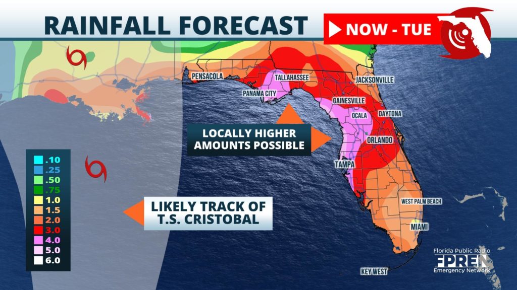
Tropical Storm Cristobal is not expected to make landfall in Florida, but its nearby moisture will produce several inches of rain over multiple days across the Sunshine State.
The downpours began Wednesday across much of Southwest Florida, then began spreading north into the Tampa Bay metro area by evening.
Tropical Storm Cristobal made landfall in the State of Campeche of southeast Mexico Wednesday. Deadly flash flooding has been reported the past few days across portions of Central American and portions of the Yucatán Peninsula.
Cristobal is expected to remain near-stationary through Thursday, possibly weakening to a tropical depression, before moving northward Friday and entering into the Gulf of Mexico this weekend. Forecasters at the National Hurricane Center say it could make landfall in Louisiana late Sunday or early Monday.
While the center of Tropical Storm Cristobal is currently expected to stay west of Florida, the large circulation surrounding it will send waves of tropical moisture from the Gulf of Mexico across the state, triggering numerous rounds of showers and some thunderstorms through at least Monday.

The heaviest rain is likely to fall near and just inland from the Gulf Coast, from Pensacola to Tampa, where at least 4 to 5 inches may accumulate over the next five days. Locally higher amounts will be possible in some areas, especially where some of the outer bands of Tropical Storm Cristobal set up when the storm is at its nearest point Sunday. Rainfall amounts across the rest of the state will generally be in the 2 to 4-inch range across the rest of the peninsula, with potentially lower amounts along the Atlantic Coast from Cape Canaveral to Miami.
The heaviest and most widespread rainfall associated with the circulation from Tropical Storm Cristobal is expected to subside by late Monday. However, the wet weather pattern may last well into next week, but potentially from another weather feature or from the afternoon sea breezes.
