- Irma now a Category 4 with winds of 130 mph
- Hurricane Warnings for U.S. and British Virgin Islands
- Could threaten much of Florida this weekend
Parts of South Florida are already in the National Hurricane Center’s 5-day forecast potential path. The official forecast, as it stands now, takes the Category 4 storm just north of the islands of Puerto Rico, Hispaniola and Cuba through Friday. Beyond day five, reliable longer range forecast data suggests Hurricane Irma will make a sharp turn to the north near or over the peninsula of Florida. A credible forecast on when and where it makes that turn, along with how strong it will be is just not scientifically possible yet.
While it’s too early to determine specific hazards any given location may experience from Irma, there are three schools of thought – we will call them “potential outcomes” – that are referenced on the map below.
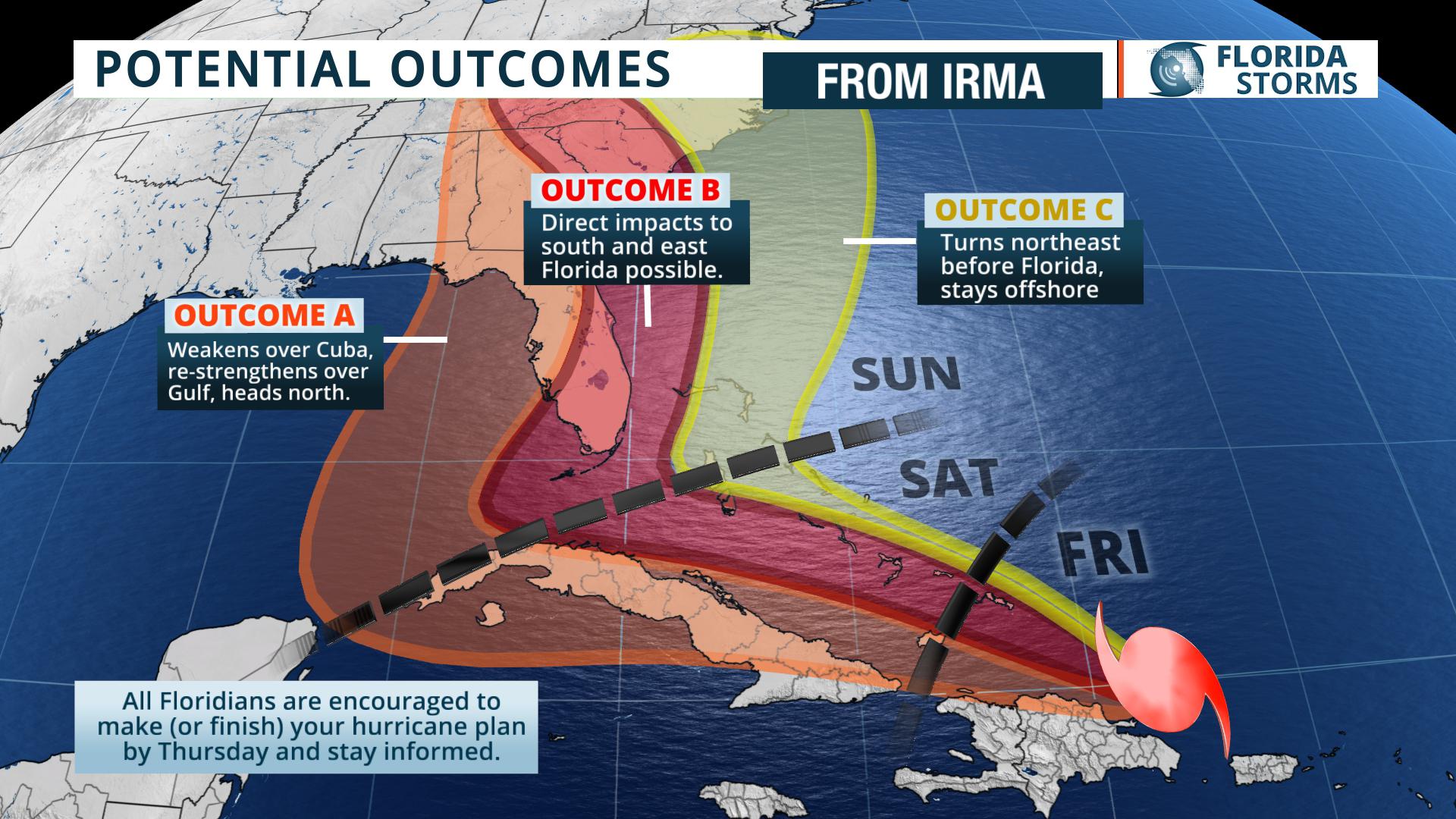
– Weakens some due to influences of Cuba or Hispaniola
– Could strengthen again over eastern Gulf
– Would threaten west coast of Florida or the panhandle
Hurricane Irma has been steered west (and even west-southwest) by a strong ridge of high pressure. Forecast models have been adjusting to this more westward track for several days, making it entirely plausible that Irma will be heavily influenced by the mountains of both Hispaniola and Cuba before making a turn to the north. It’s also possible that Irma would spend more time over warm water in the Gulf of Mexico before possibly approaching Florida’s west coast or the panhandle.– Turns sharply north near the Straits of Florida, threatens all of South Florida
– Direct impacts possible, especially the Atlantic coastline
– Could also threaten Georgia or North and South Carolina
A much sharper and sooner turn to the north is seen by several reliable long range forecast models that would place much of south and southeast Florida in the cross hairs of Irma. The storm would then generally parallel the coast, either inland or just offshore, and affect a large section of Florida’s Atlantic Coast on its way to Georgia or the Carolinas. Based on Monday’s forecast data, this is the most likely scenario and could result in millions of Floridians being told to evacuate by Friday.– Turns northeast before approaching Florida’s coastline
– Significant coastal event possible
– Most of Florida’s west side left alone
While this is the least likely scenario, it’s certainly the one that would be the best news for Florida. Hurricane Irma may drift far enough to the north to make use of an opening in the steering currents that would allow the storm to turn away from the U.S. much sooner. If this were to occur, most of Florida would be spared significant wind or surge hazards. However, the heavy rain, tornado and coastal flooding problems would likely extend up the entire eastern seaboard.


