Powered by WUFT
Temporarily change filter
Finding your station


Depression likely to become tropical storm tonight or monday.
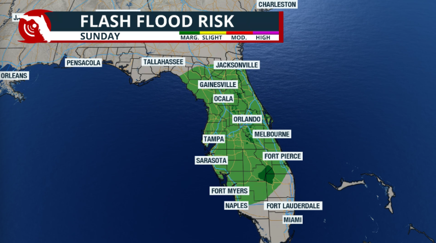
There are no coastal watches or warnings in effect.
None.
At 200 PM CVT (1500 UTC), the center of Tropical Depression Seventeen was located near latitude 13.2 North, longitude 28.8 West. The depression is moving toward the north northwest near 14 mph (22 km/h), and this motion is expected to continue today. A motion toward the northwest is forecast to begin by tonight and continue through Tuesday. Maximum sustained winds are near 35 mph (55 km/h) with higher gusts. Some strengthening is expected for the next couple of days, and the depression is likely to become a tropical storm tonight or Monday. By Tuesday, environmental conditions are expected to become less conducive for development, and the system is forecast to begin a slow weakening trend. The estimated minimum central pressure is 1007 mb (29.74 inches).
The low-level center of the depression was exposed on visible satellite imagery this morning but recently a new burst has formed. Since the morning scatterometer passes missed the depression, the intensity is held at 30 kt based on consensus T-2.0 values from TAFB and SAB.
The initial motion estimate is 330/12. The cyclone is forecast to move in a general northwestward direction throughout the remainder of the forecast period as the system moves along the southwestern and western periphery of a subtropical ridge that extends westward from Africa across the Cabo Verde Islands. No significant changes were made to the previous NHC forecast track, and the new prediction lies near the middle of the tightly clustered track models.
Environmental conditions are conducive for strengthening during the next day or so, with wind shear forecast to drop off later today. Thus, the official forecast calls for strengthening during the next 24 hours, and is close to the lower half of the intensity guidance envelope, near the weaker global models. This forecast could be conservative, since SSTs will be near 27C and mid-level atmospheric moisture will be enough to support intensification. By 36-48 hours, the southwesterly shear will increase, which should end the opportunity for strengthening, and will likely cause slow weakening. The models hold onto this system through the 5 day period, but it is possible that the cyclone could become a remnant low in 4-5 days if the shear is too much for the system to handle.
1885 Stadium Road
PO Box 118405
Gainesville, FL 32611
(352) 392-5551
A service of WUFT at the University of Florida College of Journalism and Communications


Partners of the Florida Public Radio Emergency Network include: Florida's Division of Emergency Management, WDNA (Miami), WFIT (Melbourne), WMFE (Orlando), WFSU (Tallahassee), WGCU (Fort Myers), WJCT (Jacksonville), WKGC (Panama City), WLRN (Miami), WMNF (Tampa-Sarasota), WQCS (Fort Pierce), WUFT (Gainesville-Ocala), WUSF (Tampa), WUWF (Pensacola) and Florida Public Media.
This page uses the Google Privacy Policy and UF's Privacy Policy